ARGENTINA, THE HARD WAY?
(Chillin' in Chile Part 4)
Travel Tales Index - Chillin' In Chile Index - Chile Pix
Our last e-mail had us in Chile Chico, heading down the Carretera Austral. The main reason we went to Chile Chico was for the ride down the long and winding road to Puerto Bertrand. The dirt road descends from up in the Andes almost down to sea level and skirts Lage General Carrera for part of the trip. Unfortunately, the weather wasn't the greatest, but we still had beautiful views of the lake and mountains. The Puerto Bertrand/Cochrane area is virtual wilderness, with a few fly fishing lodges along the Rio Baker. From Cochrane we went to Villa O'Higgins, the Southern terminus of the Carretera Austral.
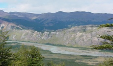
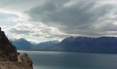 Lago General Carrera |
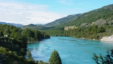 Rio Baker |
Let me tell you a little about the trip to Villa O'Higgins. It was 150 miles of unpaved roads from Cochrane. The road was built by the military and is quite rough in places. The first half of the ride was through a very arid, relatively flat, region with the road following a river. We climbed over a mountain pass and as soon as we got to the other side, the climate changed completely. It was very damp and lush, almost like a temperate rain forest. The road crossed the Rio Bravo where cars, trucks, buses, bikes, everyone... takes a 45 minute ferry ride to continue along the road on the other side of the river (ie. there is no bridge). To give you an idea of how much traffic there was to Villa O'Higgins, the ferry runs 3 times a day and can take up to 4 cars each time. Yup, that means a maximum of 12 cars in each direction per day!
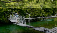
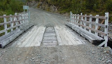 New Bridge |
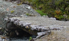 Old Bridge |
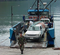 Really Small Ferry |
Villa O'Higgins has a population of about 500 and just got 24 hour/day electricity this past year. So, why did we go to Villa O'Higgins? Well, because our guide book had a little section entitled "Argentina, The Hard Way", describing how to cross from Chile to Argentina via Villa O'Higgins. How could we pass up "The Hard Way"??? It was just too much of a challenge not to! So on Friday, January 18, we boarded another ferry that runs across Lago O'Higgins to a Chilean border post at Candelario Mansilla. After a 3 1/2 hour ride, we got off the boat, walked 10 minutes and officially left Chile by getting exit stamps in our passports. Of course, we were still in Chile.
It was a 10 mile hike (with all our stuff) to the actual border. Just to make it interesting, the first 3 miles were straight uphill! Luckily, it was along a dirt road that the military had built so they could monitor the border. (The Chileans and Argentinians have a long history of border disputes and are very anxious to assert sovereignty over "their side" of the border.) One little problem with the road - one of the bridges which crossed a reasonably strong stream of Glacial water runoff was washed out. Okay, we took off our hiking boots, put on our tevas and walked across - while out feet, calves and thighs slowly lost all feeling due to the numbingly cold water. We dried off, put our boots back on and continued walking. After about half an hour or so the feeling in our legs and feet started coming back. We were lucky it wasn't a cold windy day. Leaving a pine forest, we walked into a clearing and in the distance saw a majestic peak - Mount Fitz Roy in El Chalten - our destination! Soon thereafter, we reached the official border point with a little tower and a sign that said "Chile" on one side and "Argentina" on the other. From the border, it was another 4 mile walk, this time downhill, to Argentinian immigration. So, we walked about 14 miles in about 6 1/2 hours. Pretty good time and we were proud of ourselves. I was scoffing at the guidebooks- Argentina the hard way? hah, just a little stroll in the woods!
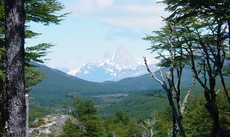 Looking to Mt. Fitz Roy, Argentina |
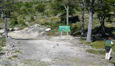 The Real Border |
That night, we camped out near the Argentinian border post along Lago Del Desierto. A beautiful lake high up in the mountains with steep snow covered peaks overlooking it. We prepared a dinner of pasta with tomato sauce and garlic, onion,green peppers, mushrooms and canned mackerel. After dinner, it was into the tent for a sound night's sleep. We were at the Northern side of the lake and there were no roads here, just another trail leading 9 miles to the Southern end of the lake. The next morning, we started out (still thinking - the hard way? hah!).
You might think a hike from one end of a lake to the other would be relatively flat. You might, I did and I was dead wrong. We hiked up, up, up and then down, and then up again for 5 1/2 hours. Okay, maybe our earlier scoffing was a bit premature! The one plus was the view of the lake and the surrounding mountains, some of which were covered with glaciers. During the day, the glaciers melted creating many streams and waterfalls - pretty to both see and hear.
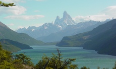 Lago Del Desierto & Fitz Roy |
 Sturdy(?) Footbridge |
When we finally arrived at the Southern end of the lake after a total of about 23 miles hiked in two days, we took care of important things first- two ice cold cokes. Then we got a ride to the nearest town and our destination - El Chalten, Argentina, in the center of Parque Nacional Los Glaciers. El Chalten was created by the Argentinian government to assert sovereignty over their side of the border but has turned into a major trekking center. The size of the town has been doubling every 2 years for the past 6 years or so. When we arrived, there were more buildings under construction than already existed and there was still a shortage of places to stay. We stayed in dorm rooms which were $9 per person. Private rooms cost a minimum of $40 and were all sold out!
Our first day in El Chalten was spent on R&R. Had our laundry washed, relaxed, changed money etc. Dinner was at a Parilla. Basically, an Argentinian steakhouse where they cook the meat over a wood fire. Excellent steak and for Lois,trout. We visited the tourist office and were given a topographical map with a list of all the area hiking trails and the elevation gains. Hiking is about the only thing to do in El Chalten. It was a bit unusual to be in a town with no shopping, no entertainment, no "touristy" options, no roads that take you right to the mountaintop. If you come to El Chalten, it is to hike and nothing else. Just about everyone in the street has either a daypack or a full backpack on and is headed hiking somewhere.
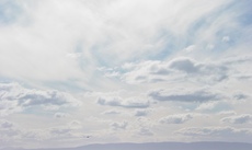
Naturally, we spent the next couple of days hiking. Great views of Mount Fitz Roy and other peaks in the area with the sun shining off of them. Views of El Chalten below on one of our hikes up to a glacier. The skies were amazing. Shapes and forms of clouds I had never seen before plus more shades of blue than I knew existed. The clouds had multiple layers and you could see clouds going in 2 or 3 different directions at the same time due to the strange winds. When we headed to El Calafate (Argentina), our next destination, we drove about 150 miles across Patagonian steppe. Flat for as far as you could see - true big sky country. We were east of the Andes and most of the moisture doesn't make it across the mountains so it was very dry - mostly scrub brush and mostly brown.
 El Chalten Valley |
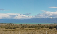 Patagonian Steppe |
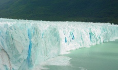
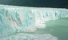
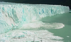
El Calafate was in many ways the complete opposite of El Chalten. It was a "tour bus tourist" type of town. Many people flew in just for a day or two, there were a number of first class hotels, lots of shopping, souvenirs etc. Quite a shock to the system after all the small towns we had been in. The attraction in El Calafate was Perito Moreno, an advancing glacier that is about 30 miles long and 10 miles wide. It was a 2 1/2 hour ride through more patagonian steppe to Perito Moreno, then we took a boat which came within 300 feet of the glacier face (any closer might be dangerous if the glacier calved a large piece of ice and created a tidal wave). The glacier's face varied from 90 to 200 feet in height. Pure solid ice, some of it blue. This is due to the weight of the glacier compressing itself so that the ice is so dense it absorbs all colors of the visible spectrum except for blue. However, don't think of a glacier as a large ice cube. It definitely was not. The glacier was formed by wind, snow and rain so its surface was anything but smooth. There were large, 50 foot deep crevices in parts and the top was a huge series of craggy peaks. There were all sorts of striations and lines through the face, similar to the side of a rock cliff.
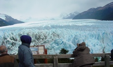
Looking Over Perito Moreno Icefield
After the boat ride, we went to another area where there were a series of boardwalks and balconies overlooking the glacier's face. We basically sat there and watched, in awe, as various sized pieces calved. Sometimes, the pieces looked so small, but the sound and wake when they hit the water was unbelievable. Of course, in the lake in front of the glacier it looked like iceberg stew with all different sizes and shapes of icebergs floating around.
 Glacier Calving |
 These Photos |
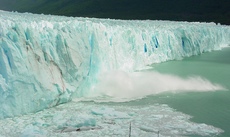 Cover About 15 Seconds |
 Of Action |
From El Calafate, we headed to Rio Gallegos (Argentina), crossed the border back into Chile (the easy way, by bus) and went to Punta Arenas. This was as far south as we would get on this trip. For me, one of the most interesting things we saw in Punta Arenas was the cemetery! It reminded me of the Colon Cemetery in Havana. In the late 1800's, the Punta Arenas area was not claimed by any country. Immigrants from all over Europe came and settled. Walking through the cemetery, we saw German, Scottish, English, Russian, Yugoslav, Czeck, Portuguese, Italian, French and Spanish graves and masoleums. Many of these families live in the Punta Arenas area to this day.
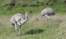
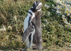
On January 26, 2004 our friend JoAnne flew into Punta Arenas to join us for the rest of our trip. After taking a walk around and looking over the Straights of Magellan, we lined up a tour to a penguin rookery. We wanted to go to Isla Magdalina which was home to over 70,000 penguins. Unfortunately, due to high winds, the tours were cancelled. We settled for Otway with 10,000 penguins which was a 1 hour drive from Punta Arenas. Along the way, the driver did an excellent job of stopping and letting us get photos of various birds and the beautiful landscape. I was disappointed in the actual rookery. I wanted to see a place where penguins covered every square inch of ground. Otway didn't come close, but we got to see some penguins and it was pretty comical to watch a couple of them waddle along. Mostly, they just stood there, like sentinels, with their backs to the wind.
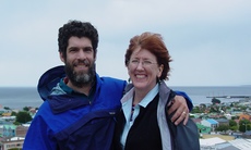 Lookout Over Punta Arenas |
 Look At That Sky! |
 Roadside Rhea |
 Magellanic Penguin |